
Go with the Flow
9/17/2026 | 26m 46sVideo has Closed Captions
Tracking plastic trash, flood zones, moving sharks from an aquarium and preventing overdose deaths.
Tracking trash from our rivers to the ocean, a look at the hidden risks in flood zones and how sharks and other aquatic animals are transported through aquariums. Plus, UNC Research studies how to prevent deaths from drug overdoses.
Problems playing video? | Closed Captioning Feedback
Problems playing video? | Closed Captioning Feedback
SCI NC is a local public television program presented by PBS NC
Sci NC is supported by a generous bequest gift from Dan Carrigan and the Gaia Earth-Balance Endowment through the Gaston Community Foundation.
Go with the Flow
9/17/2026 | 26m 46sVideo has Closed Captions
Tracking trash from our rivers to the ocean, a look at the hidden risks in flood zones and how sharks and other aquatic animals are transported through aquariums. Plus, UNC Research studies how to prevent deaths from drug overdoses.
Problems playing video? | Closed Captioning Feedback
Where to Watch SCI NC
SCI NC is available to stream on pbs.org and the PBS app.
Related to This Episode
Providing Support for PBS.org
Learn Moreabout PBS online sponsorship- Coming up on Sci NC why GPS is tracking trash, the hidden flood risks lurking outside the flood zone, and what it takes to move sand tiger sharks from an aquarium, next.
- Quality public television is made possible through the financial contributions of viewers like you, who invite you to join them in supporting PBS NC.
- Sci NC is supported by a generous bequest gift from Dan Carrigan and the Gaia Earth Balance Endowment through the Gaston Community Foundation.
(gentle music) ♪ - Hi, and welcome to Sci NC, I'm Laura Smith.
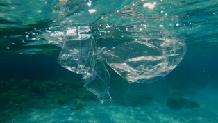
Plastic is polluting our waters.
In fact, it makes up the bulk of marine debris, almost 2 million tons.
Producer Frank Graff shows us how researchers wanna learn more, tracking trash with GPS from rivers to the ocean.
- Inspired by a disturbing discovery, Madison Haley is now on a mission.
- I love kayaking, and so I spent a lot of time on the Haw River in my kayaks with friends and family, and I started noticing how much trash there was everywhere, and I am a little bit of a nerd, so I love maps and graphs, and so I started collecting data about all the trash that I found.
- You could call it litter math, focused especially on plastic bottles.
- I was shocked that about 40% of those bottles were water bottles, which was a little bit really sad and kind of like painfully poetic of this beautiful river is being polluted by bottled water, and so that kind of like really spoke to me.
- And that's why, as part of her graduate work, Haley is leading researchers to litter with a purpose.
- Yeah, so this is a bottle.
This is meant to be a fake litter bottle.
We are littering them, but we're tracking them, so if I open this up for you, they're full of, these are actually cornstarch styrofoam, so not plastics.
- That packing protects what makes the Littering for Good project so unique.
The 20 bottles that were sent floating down Marsh Creek carry a GPS tracking device and a scannable QR code.
- These communicate with my computer and all of our research team's computers, and we actually update a public dashboard.
So all of these bottles are floating down the creek into the river, and the GPS trackers are telling us where they are.
- The idea is to follow how everyday litter in Raleigh winds up polluting creeks and rivers, and eventually traveling the 200 miles to the Pamlico Sound, and eventually the Atlantic Ocean.
- And so we'll see how fast they travel.
I think we're hoping that, I mean, hoping is a weird word to use, but we are hoping that they go all the way to the ocean so that we can understand how fast they move, but they do get stuck in all those log jams.
If you go into a creek, especially an urban creek, you'll often see these big piles of trash.
That trash gets stuck there, and it sits there potentially for a long time, and we'll be able to understand how long that trash kind of sits around, degrades into microplastics, or how fast it's moving downstream to other communities in the ocean.
What we're finding is a lot of this litter is coming after rain events, so when the rain comes down, the stormwater all flows into local creeks and streams, and it brings with it all the trash that's on our roadsides and our environments.
And we are finding that the bigger the rainstorm, the more trash there is because the more water is kind of bringing all that litter into the trash traps, and we're looking more into those patterns with our research.
- Scientists estimate as much as 2 1/2 million tons of plastic are added to the ocean every year, and much of it is litter that washes from streets and parking lots into creeks and rivers, and then to the sea.
- So we're trying to do both research and education.
We're figuring out if this plastic bottle gets into the creek, how far does it go?
People not even making that connection, like from the parking lot, the roadway, the sidewalk, into the storm drain to the creek, but once in the creek, how far will it go, and what's the condition of it when it ends up in the sound?
- Data shows that plastic bottles traveled almost 30 miles downstream in just two months.
A quick pace was helped along by several large rain events.
- So anytime there's a big rainstorm and there's a lot of runoff from different parts of the city, we definitely see the volume in trash and our traps go up just because the flow rate of the streams and the rivers are higher, so that trash is moving faster and making its way downstream.
- Plastic waste is actually a two-fold trash problem.
While large pieces of plastic trash degrade the environment, each piece of plastic sheds microplastic fragments that can absorb toxins and also enter the food chain.
Earlier studies found microplastics in sample sites all along the Neuse River.
- So macroplastics, the big pieces, can be so devastating to aquatic ecosystems, to habitat, and to all of the fish and the food for fish that they rely on.
Those macroplastics get, you know, animals get caught in them, they get tangled up in nests and woody debris, and that's where all of the aquatic insects like to live.
And so they can destroy an entire aquatic ecosystem by just kind of creating havoc in homes and getting in the way of the ability for fish to actually hunt and get food.
But for us humans who eat fish and for us humans who eat other critters that are in our aquatic systems, the microplastics are the biggest problem because we can see and pick out macroplastics and they're gross and we don't wanna interact with them.
It makes us not wanna touch the water.
But the microplastics are the things that build up in our bodies.
And so we don't see them, those are the invisibles, but when we eat fish or when we go swimming in a waterway and accidentally drink a little bit of water, or you know, those bioaccumulate in our bodies and they affect us in so many ways.
- The plastic bottle tracking is just one part of a larger study about litter.
It involves trash traps to identify the volume of plastic debris, microplastics counting, and studying the behavior that leads to littering.
Researchers hope to identify practical solutions to stop litter before it enters waterways.
- You know, we really wanna make that connection for people that actions here in Raleigh, littering that happens here has a consequence, right?
Locally to our Marsh Creek, to our Crabtree Creek, but also downstream to the Neuse River.
- After I saw this next story, I looked up my own address and learned my real flood risk wasn't the one I expected.
Researchers at UNC found nearly half of North Carolina's flood damage happens outside the FEMA maps.
Producer Evan Howell shows us how they're finding those hidden risks to better protect communities.
(water rushing) - There's a real science to how flood waters move.
They begin in the channel and spill into the natural flood plains.
But when that's full, water finds paths across streets, fields, and yards, sometimes sweeping into places that the Federal Emergency Management Agency never accounted for.
But more recently, it's just heavy rain that inundates these areas.
When we picture flooding, we often think of rivers spilling into neighborhoods, pooling in places people never expected.
- So typically, when we think about where it can flood, we think about the riverine floodplain.
Imagine that you're standing in a river and you're looking up and down.
You may have some houses out here on the riverbanks, and we consider how high could the river rise during a given flood event.
So perhaps this floods from a riverine flood.
But you can also have really heavy rainfall falling way out here.
And if that rain falls at a rate that's so fast that it can't run off in time, this house can also flood.
- In a groundbreaking study, researchers at UNC Chapel Hill went back and analyzed 25 years of floods in North Carolina.
They mapped 78 separate events between 1996 and 2020, and discovered that nearly 90,000 buildings, or almost half, were outside of FEMA's mapped flood zones, places that weren't expected to flood.
The FEMA maps are used to guide planning, and they highlight areas where the odds are higher that water will go over land.
But the research has revealed just how widespread flooding has been across the state.
- Like the coast is a really good example of those places where we know it floods a lot, but our study, we found a lot of flooding inland as well.
So kind of unveiling those hidden areas of flood risk and where flooding has happened in the past.
- It's important to remember, FEMA's flood maps are probability maps, not historical records.
They reflect only the likelihood of flooding, like a 1% annual chance based on past data.
But flood risks evolve, and those blue lines are not guarantees.
- And there's a lot of floods that are bigger and smaller than that 100 year flood.
And this is just a different form of information of where it's flooded in the past.
And that's usually a good indicator of where it might flood again in the future.
- So why does it look like these maps miss so much?
One answer lies in what they're designed for and what they're not.
- Our objective was really different than what the FEMA maps are doing, right?
The FEMA maps are a regulatory tool that's designed to communicate something about risky places.
And they're also designed to help determine how we use those risky places, like what the land uses of those places are, how we build, what we build, what that looks like.
Our study was really aiming to try to fill gaps in the historical record of floods.
So we have very little data on where it has flooded in the past.
That's something different than what the FEMA maps are doing.
- FEMA floodplain maps are meant to guide us, showing us where rivers may rise or where a storm surge may spill over the coast.
But here's what they don't show.
The flooding that comes when extreme rainfall overwhelms communities far beyond those lines on the map.
We've heard about the 1,000 year flood event, for example, or as FEMA says, has a 1% chance of happening.
But as this map of the French Broad River at Asheville shows in blue, the area where flooding can happen is pretty wide.
And it's getting more common.
In the UNC approach, they use machine learning and geographic data to reconstruct flood footprints, even for uninsured homes or events that don't make headlines.
That expanded their perspective beyond just disasters like hurricanes.
So doctor, you guys work with a lot of different maps that tell us a lot of different things.
What kind of a map is this?
- This, what you're looking at right here is the North Carolina Flood Risk Information System.
It is a website or a web tool that any homeowner in the state of North Carolina can go to and see where they are located relative to the regulatory floodplain map.
So you see here a bunch of building locations, and you can see their location relative to the regulatory floodplain.
Importantly, this doesn't tell you what has flooded in the past, but it does give you a sense of what could flood in the future.
So it's important to know that if a property is located inside of a floodplain and has a federally backed mortgage, they're required to buy flood insurance, but even properties outside the floodplain can flood during a flood event.
So this doesn't tell us anything about where it's flooded in the past, but it gives us a sense of what could flood with a high probability.
- So for residents outside FEMA zones, that can create a false sense of safety, but the risk is very real, and when floods hit, families often bear the full cost.
These UNC maps don't discard FEMA maps, they reframe them.
Researchers dug deep.
They went back and looked at insurance claims and damage records all the way back to the 1980s, and with that new information, they were able to lay down exactly what flooded in North Carolina.
- I hope it's helpful for property owners, even renters, to kind of figure out their flood risk in their area and help them make more informed choices about maybe if I'm not in one of these flood zones that requires insurance, maybe I go ahead and purchase it anyways, because that's really the first form of defense for a lot of people.
- UNC researchers say the path forward is unmistakable.
Better data, smarter maps, stronger communities, because floods don't wait for updates.
If you're curious about your own risk, head to fris.nc.gov to see how where you live lines up with these FEMA flood zones.
- How do you move sharks?
Very, very carefully.
The Fort Fisher Aquarium did just that to prepare for a big expansion, one that's going to make it the largest in the state, but it's also part of the fight to save these endangered sand tiger sharks and other species too.
Take a look.
[indistinct talking] - Extracting sharks out of a 235,000 gallon water tank that's about 23 feet deep isn't a small task.
But staff at the North Carolina Aquarium at Fort Fisher executed the task with precision, keeping animal health and safety in mind.
- Fortunately, again, it went very smooth.
I think we had both animals out of the water, I believe, in at least less than three hours.
- Marc Neill, an aquarist at Fort Fisher, was in the tank during it all.
- They're just the power of those animals.
It's something that you don't normally get to experience unless you're in the water with them.
♪ - And he sure felt the power of the sharks on move day when he and his team pulled two sand tigers out of their habitat, one weighing 282 pounds, the other 165 pounds.
- The two large animals that we had, they recently were transported to two of our sister facilities.
- This to give the sharks more space to swim and grow, but also ahead of a major renovation project at the aquarium.
- Then the whole idea of doing kind of the way we were doing it is, we don't wanna chase them around.
You're not trying to spook them, you don't wanna scare them.
'Cause again, that increases that stress level on that animal.
It's a well-oiled machine.
And again, all of that was basically for that specific purpose, minimizing the stress on those animals, trying to facilitate an easy extraction.
- From there, a crane lowered the sharks into a mobile tank for the drive to their new homes.
- Once the large animals were removed, then it was time to start planning, introducing the small animals.
- Neill's team at Fort Fisher welcomed three young sand tiger sharks from New England, each about four feet long and up to 27 pounds.
They'll swim here until a new 400,000 water gallon tank is built.
- Once it was time for them to leave New England and come here, we essentially outfitted a truck and put together three separate life support systems, essentially, and then went into one of our holding facilities for a little bit of time, again, just kind of making sure they took the move well, they're settling in, they start eating.
- And since the move, the young sharks have been eating well, but observation continues.
- Sand tigers are kind of unique among other sharks where they actually use air to maintain their buoyancy.
And oftentimes they can, you know, maybe not always get that perfectly right.
And so we're just, especially when, you know, if they come out of the water, they'll burp it out.
So then they have to gulp it back in.
And so just kind of watching them and making sure that they are adjusting in terms of getting their buoyancy.
They're swimming without any real heavy, you know, exaggerated movements, anything that would just indicate that they are not comfortable or, you know, something isn't 100% right.
♪ or, you know, something isn't 100% right.
♪ - So why is there such a big focus on sand tiger sharks at North Carolina aquariums?
One, they're very common off our coast.
And two.
- They were fished pretty heavily in other parts of the world.
And so they're highly endangered species.
♪ And so they're highly endangered species.
♪ But one of the things that makes sand tigers sort of a conservation focus is they have a very, very, very low reproductive rate.
- In fact, he says only two pups are born every other year, making it difficult to grow their numbers.
- Sand tigers, in each of those uteri, they will start consuming each other.
♪ There are several sharks out there that actually, the female, the mother will supply eggs, which the embryos will feed on those eggs to nourish and grow.
But sand tigers go to that next extreme where they actually eat their siblings.
- Neill says breeding sand tigers in human care is a challenge.
- As of now, we're aiming for an all female population.
And the hope is that we may potentially be able to support some of the artificial insemination type work.
And so where they would be collecting sperm from males in the wild, and then implanting that into females.
And then the hope is that you can actually achieve parturition through that process.
♪ parturition through that process.
♪ - Protecting sand tigers requires more than managing them in human care.
Scientists need to understand how they behave in the wild.
(beeping) - So what is this telling you?
- So that is telling me that that's a known individual.
- Karissa Bearer is the aquarium's education curator and part of a research network tracking sand tigers along the entire East Coast.
- We are studying sand tiger sharks, and we've provided acoustic arrays, which are installments of machinery underwater that can track animals that have been tagged with an acoustic tag.
♪ - Each time a tagged shark swims past one of those receivers, it pings.
(beeping) Logging the animal's location, movement, and timing.
- Really important for understanding migration patterns seasonally between males and females or age gaps.
- Data fills in critical gaps, including one question that could be key to the species' survival.
- Also hoping to figure out where they're breeding.
And not only will that help us with the population numbers, as I mentioned before, but it also helps us understand better how to manage the coastal waterways for shared use.
- That kind of population level science takes years to build and sand tigers aren't the only species here that need it.
♪ Coral reefs, which support roughly 25% of all marine species are in serious decline globally.
And like sand tigers, one of the biggest obstacles is biology itself.
Corals grow very slow.
- So zoos and aquariums and other conservation organizations have been working with corals in-house to learn a little bit more about how we can create an ark for them or make them more resilient to some of the challenges that they're facing.
There's a lot of genetics work in that, but there's also propagation strategies.
- And here's where the magic happens.
The North Carolina Aquarium is growing coral, which will eventually make its way into its new home of a 10,000 gallon habitat.
Coral is alive.
- It is alive, yeah.
It's an animal.
So all of these are made up of individual little, what we call polyps.
Coral colors and pigments are a fascinating part of their biology in that partly they're getting that from the algae that lives in their tissues.
So when you hear that term bleaching, that's when they're not doing well.
That's when they expel that and they end up kind of turning white so you can actually see the skeleton.
♪ - NOAA says the world is in the midst of its fourth global coral bleaching event.
Adding between January 2023 to September 2025, bleaching level heat stress has impacted nearly 85% of the world's coral reef areas, the biggest to date.
- The loss of corals is at a very high rate.
I don't wanna say doom and gloom, but it's an extreme uphill battle.
- But the work happening in these tanks is part of the fight.
The expanded coral habitat is coming as part of a massive renovation and expansion at Fort Fisher that will make it the largest aquarium in North Carolina.
♪ that will make it the largest aquarium in North Carolina.
♪ Director Joanna Zazzali says it will allow guests to get up close and see what it's like under the ocean.
- Most people don't ever get that opportunity unless you're a scuba diver.
- The renovation means a temporary closure, but not a closure of its mission.
- What we decided to do was stay engaged with the community.
And how do we do that when we're closed?
- The answer, a free pop-up aquarium at Independence Mall in Wilmington.
- Inspire people to fall in love with nature.
I always say that's the most important thing.
And once you fall in love with something, all you wanna do is protect it.
That's why we're here.
And that's what we'll be able to do on a much larger scale by increasing our footprint.
- North Carolina has lost too many people to overdose and behind every number is a family.
Now a UNC lab is testing street drugs like fentanyl for the dangerous contaminants inside them.
Reports aimed at confronting the opioid crisis and keeping neighbors alive.
Here's UNC research.
- Part of the reason why we started testing street drugs is because we don't find out what's in the drug supply until it's too late.
People are either dead or they're arrested.
There's no opportunity for prevention.
There's no opportunity for recovery.
We can do better.
My name is Nabarun Dasgupta I'm a senior scientist at the University of North Carolina in Chapel Hill.
Every morning we come into the lab and there's a dozen packages from around the country waiting for us.
Those packages contain the drug samples that have been sent to us for analysis.
We do some basic steps to clean up the drug sample so it's ready to load onto our instrument.
What this very fancy machine does is figures out exactly what's in that drug sample down to the atomic level.
And we're able to put those results out both back to the individual and the groups that send us the samples, but also aggregate the data so that we can see trends across our state and really across the country.
Our fundamental mission is to make our neighbors healthier.
We want people to make better decisions about what they put in their bodies.
Science can help with that.
Our goal is really science and service.
We serve over 160 programs in 43 states.
What we are doing here on campus has repercussions all over the country.
- Trends observed by the lab have helped us understand that we need to intensify our work because the amount of people who are dying or being impacted by overdose is still too high.
My name is Charlton Roberson and I'm the Eastern Regional Coordinator for the North Carolina Harm Reduction Coalition.
The North Carolina Harm Reduction Coalition is a grassroots organization in North Carolina that provides life-saving services to individuals who are impacted by substance abuse.
- Organizations like Charlton's are absolutely essential because they are the last mile.
They are the ones who have direct connection to the communities they live in, the communities they serve.
As the overdose crisis ramped up in the United States over the last few years, we were faced with a second crisis, which was that the antidote itself was getting to be too expensive and too subject to the whims of the supply chain and there were shortages.
We set about to fix this.
We created a non-profit to provide bulk naloxone distribution to frontline public health programs with very low overhead and very rapidly.
This allows programs to have access to enough of the antidote to actually make a difference in the overdose death rates in their communities.
- Nab and his crew at Remedy Alliance have been very, very useful to us and impactful to us in providing us with Narcan and also other things like xylosine and fentanyl testing strips that we can pass out to individuals and canisters of oxygen.
- We still have a long way to go.
We're still losing way too many people we love in North Carolina.
And I think with the tools that our lab and our community partners bring to the table, we're changing what's happening on the ground here.
- And that's it for Sci NC this week.
If you want more Sci NC, be sure to follow us online.
I'm Laura Smith.
Thanks for watching.
We'll see you next time.
(gentle music) ♪ ♪ ♪ ♪ ♪ ♪ - Sci NC is supported by a generous bequest gift from Dan Carrigan and the Gaia Earth Balance Endowment through the Gaston Community Foundation.
- Quality public television is made possible through the financial contributions of viewers like you who invite you to join them in supporting PBS NC.
Video has Closed Captions
Tracking plastic trash, flood zones, moving sharks from an aquarium and preventing overdose deaths. (20s)
Providing Support for PBS.org
Learn Moreabout PBS online sponsorship New Episode
 New Episode
- Science and Nature

Explore scientific discoveries on television's most acclaimed science documentary series.
 New Episode










Support for PBS provided by:
SCI NC is a local public television program presented by PBS NC
Sci NC is supported by a generous bequest gift from Dan Carrigan and the Gaia Earth-Balance Endowment through the Gaston Community Foundation.